The lost Vikings
1998 

 In
the year 1000ad, Viking colonists started to immigrate to North America from
Greenland.
In
the year 1000ad, Viking colonists started to immigrate to North America from
Greenland.
By 1345 the last Viking set sail from Greenland and its written in the annuls of Greenland
that they left the christen faith and took up the American way.
To me it looks like they left Greenland and sailed to their new colony, North
America where they found a green land
. It's here were they lived together with the Indians until Columbus discovered
America. The most famous kingdom was the green land of"Vinland the Good"
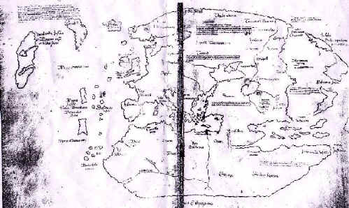
and the most controversial map in the world is "the vinland map".
I don't see the problem with the vinland map, just match it with a modern map. When
you have a match , you have vinland , Valhalla or what ever name you wish to use.

This is the Vinland map, the most controversial map in the world.
It leaves us to believe, there where
"Vikings in America"
In order to get the most from my theories you should read all the same legends and
books I ' have red .
Follow this link to an index to webs and
books which relate to lost lost Viking kingdoms.
the next few paragraphs are a brief intro to the discovery of Vinland and a few of the
resources they found.

 Before
you start the 1998 WebPages , have a look at my 2006 discovery in the paragraph below.
Before
you start the 1998 WebPages , have a look at my 2006 discovery in the paragraph below.
January 2007
My story is simple, 20 years ago I said "the
Vikings Made a town at the base of this mountain."


For 20 years I have been told ,"no they did
not"
In 1997 I decided to put my theory on paper so I could have my discoveries documented
, and maybe convince someone ,I found vinland , unfortunately it was
just theory, not enough for proof.
That was how this web started, I was trying to prove the Vikings came and settled
here.
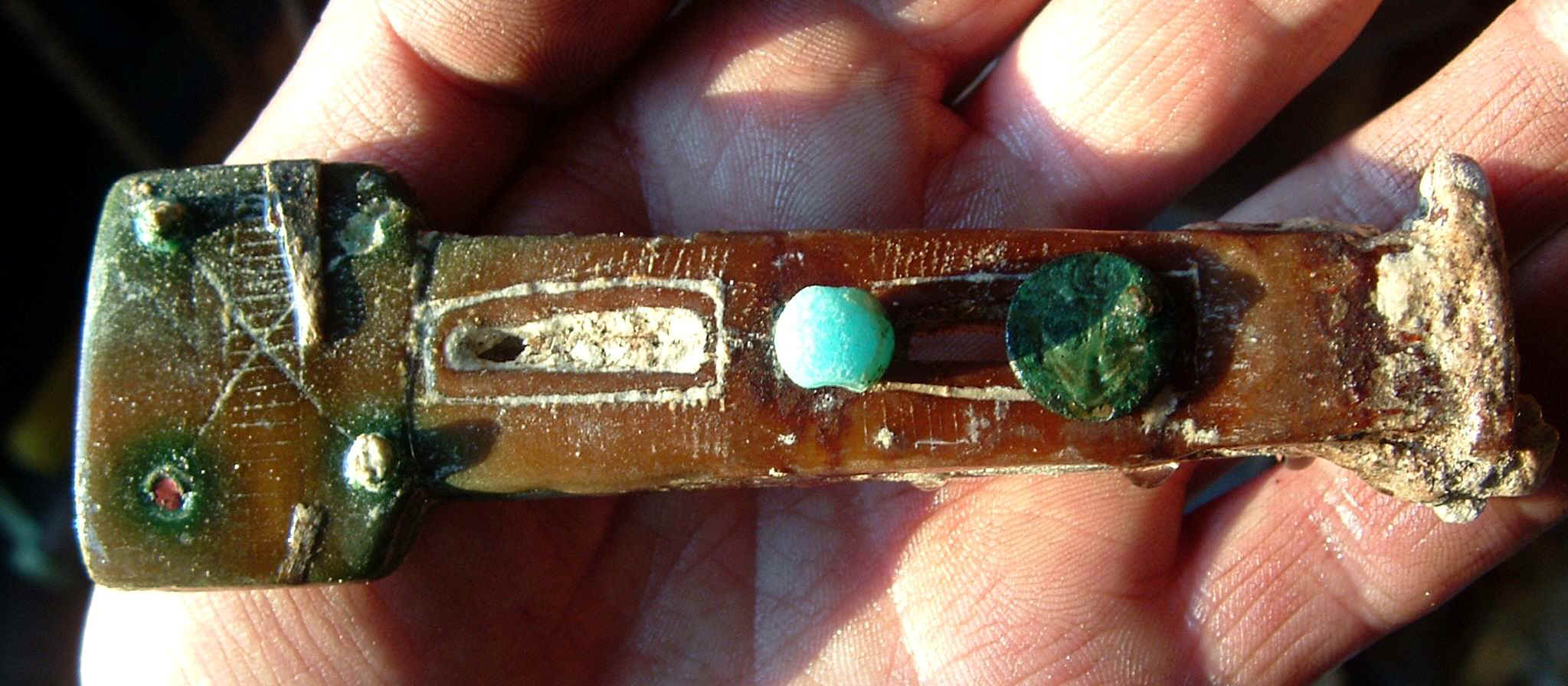
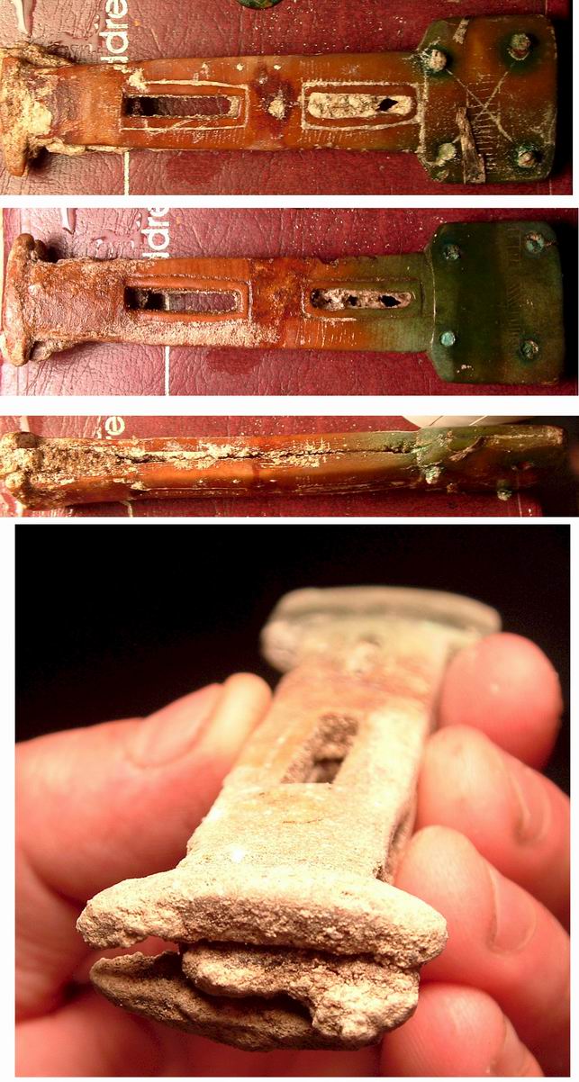
Proof would be like finding a 10 th century Viking anchor, like the one in the
picture, it was found in Europe.
Its Jan 31 2007 and I have some proof and I found it
while following the path of sir Francis drake and the Spanish. 
I never found a anchor, but I found 3 items I feel could be the proof I needed. a
pin of a Viking anchor, a soapstone dagger with a bone blade and a half of a bead.

If you have any ideas as to the date of these items, I could use the
help. the pin could be very early Spanish or it could be Viking, the
dagger handle has copper rivets so the anchor and pin could be the same age. The
half bead looks turquoise and it is very old and warn. With what i have
uncovered in the last 20 years shows , what I have here, is just the tip of the iceberg.
Last summer, I bought a metal detector and set out to search for proof of drake
and may have acidently found proof of Vikings on Vancouver island.
I feel its Important FOR ME to press publish on this page IN MY BOOK .
to find this page just type on google forest.facts.tripod someone will take
you here.
http://forest.facts,tripod.com
Read my story from 1998 and decide for your self, have I found Vikings who came
from the north .
To see a panoramic view around the sites, hit the small view picture next to
the picture's in my web.
 This
is a good one to start with, its the view from a historical winter artesian spring.
Ponce deleone stood on this site and called it paradise.
This
is a good one to start with, its the view from a historical winter artesian spring.
Ponce deleone stood on this site and called it paradise. I believe Francis drake drew the vinland map when he had his artist draw the
other exploration maps. It was probably stolen from the hidden maps of sir Francis drake.
I believe Francis drake drew the vinland map when he had his artist draw the
other exploration maps. It was probably stolen from the hidden maps of sir Francis drake.
He drew the vinland map because he knew he found, vinland the good..
The lost Vikings
1998
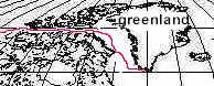 Leif Erikson clearly describes the direction and voyage. He states,
'' They left the southern part of Greenland, and sailed in a northerly direction till they
hit a large island," "They then went up and looked about in fine weather.
Then they sailed through the Sound which lay between that island and the cape which
projects northward." These direction's can only imply they sailed north
to Baffin Island, then they took the northwest passage "West" to
Alaska.
Leif Erikson clearly describes the direction and voyage. He states,
'' They left the southern part of Greenland, and sailed in a northerly direction till they
hit a large island," "They then went up and looked about in fine weather.
Then they sailed through the Sound which lay between that island and the cape which
projects northward." These direction's can only imply they sailed north
to Baffin Island, then they took the northwest passage "West" to
Alaska. 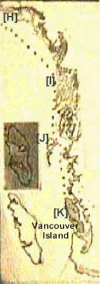
Then they sailed westward around the cape of Alaska to Helluland [H], a barren
land with arctic foxes and massive herds of rain deer.
From there they sailed south east to Markland on the 58 parallel.[I] An Island lay to the
south. 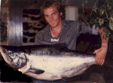 This would be the queen charlotte islands[J]. From this
Island they sailed southeast to Vinland.[K]
This would be the queen charlotte islands[J]. From this
Island they sailed southeast to Vinland.[K]
An island on the 49th parallel, where they found trees as big
as houses,
salmon larger then anything they had ever seen. On this island a berry droops of a vine
and makes the best wine. A place so mild, no snow covers the ground during the
winter and it's a 3 month voyage from Greenland. .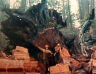
How can you get lost using these directions.
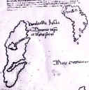 I have studied the Vinland map and compared it with a modern map. If
you look at the Vinland map, you will clearly see that Vinland lies to the south west of
Greenland. The Vinland Map
looks like it’s been drawn from a globe. Africa is cut in half, signifying its beyond
the round of the earth and India is in the right spot if you viewed the globe from
the north. If this were true, the Vikings would have known North America could not be seen
on this side of the map, it would be on
I have studied the Vinland map and compared it with a modern map. If
you look at the Vinland map, you will clearly see that Vinland lies to the south west of
Greenland. The Vinland Map
looks like it’s been drawn from a globe. Africa is cut in half, signifying its beyond
the round of the earth and India is in the right spot if you viewed the globe from
the north. If this were true, the Vikings would have known North America could not be seen
on this side of the map, it would be on the other side
of the map {world}. In order to see the island of Vinland in its true form ,
you would have to flip over the map and the mirror image of the island would be
accurate. [hold the map up to the sun and look trough it to see its true form.] Being
a prospector I can totally relate to this, It would be like a lock on the map with the key
on the flip side. After all they had to protect their new resources.
the other side
of the map {world}. In order to see the island of Vinland in its true form ,
you would have to flip over the map and the mirror image of the island would be
accurate. [hold the map up to the sun and look trough it to see its true form.] Being
a prospector I can totally relate to this, It would be like a lock on the map with the key
on the flip side. After all they had to protect their new resources. 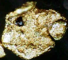 The next step
would be to take the island and compare it with the islands on the west coast of North
America till you find a match. Once a match is found, check that the resources and
the directions left behind by Leif Erikson also match , if every thing matches, you should
have found Vinland.
The next step
would be to take the island and compare it with the islands on the west coast of North
America till you find a match. Once a match is found, check that the resources and
the directions left behind by Leif Erikson also match , if every thing matches, you should
have found Vinland.
For fun, lets try compare Newfoundland to Vinland, to make a long story short
"nothing matches".
The search continues.
We will first start with the largest island on the west coast of North America.
"Vancouver island"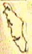
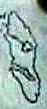
What a suprise , We have a match.
I have compared the resources they found in Vinland, with resources on
Vancouver Island.
I'm left with one conclusion.
The "Island of Vinland "can only be "Vancouver island."
The resources they found match only Vancouver island.
The two Islands are identical.
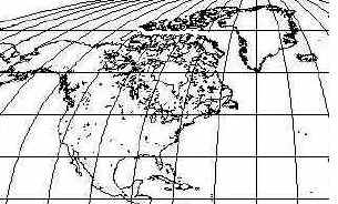
The map of North America above shows Vancouver island in the same spot as Vinland is on
the Vinland map. Both islands lie far to the south west of Greenland.
The Vinland map has text that clearly states "Vinland lies far to the south in the
western most ocean". The Atlantic lies east of Greenland not west.
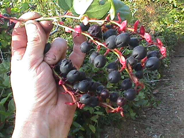 This is a quote from the vinland sagas refering to their grapes
["When the scots came back one of them carried a bunch of wine
berries and the other an ear of wild wheat"]
Vancouver island has wild berries growing of vines, that make the sweetest wine and
whild wheat grows on the west coast beaches.
The salal berries bushes would look like a thick mat of wine berries covering the forest.
The salal stems would amount to more vines then a thousand ships could hall home.
Unfortunately the grapes of Vinland were so plentiful that it turned this newly developing
kingdom into a bunch of babbling drunks.
I could present tons of proof, but if your only willing to agree to disagree, why should I
bother.
If you are willing to listen and learn, their is much more.
I can point you to people who have written long thesis's proving Vinland lies in the
pacific ocean.
http://www3.telus.net/JNHDA/1aintro.htm
The problem is other scientists debate the proof and call it theories. Then they argue
about it till they "agree to disagree".
http://www.mcri.org/vm_shroud_update.html
If someone uneducated like me makes the statement "Vinland on the Pacific" all
it would take is one spelling mistake and Their would be ground's to agree to
disagree.
My story is from the uneducated, its short but its the obvious
explanation. I don't want you to read it, then decide to agree to disagree,
just read it and enjoy it.
- REMEMBER - Nothing ever rely gets lost. Sometimes you just cant find it.
"IF
YOU WANT TO CONTINUE THE STORY" [Eilly Sport 96]
visit http//forest.facts.tripod.com
To help me uncover the mistry contact Peter at the viking navy,
To visit his page go to ---------------------
