Vinland Rediscovered Paul 1996
Edited by Dr. David
(This report is
dedicated to my co-researcher, Monica)
Discovery: Sometimes
its finding something for the first time: But sometimes it'’ finding something
important that has been lost, like King Solomon’s mines or Noah’s Ark. Discovery is a word that sets the blood
moving….
Parks
Canada thinks that Vinland was discovered in Newfoundland.
They made a park at L’Anseaux Meadows to show off the discovery. While in reality, Vinland is out here on the other
side of Canada, in another park that was set up simply to showcase the beauty of the West
Coast.
How
dare anyone question the wisdom of those experts? Well,
Vinland was a name given by Vikings to a place they found and the way to locate Vinland is
therefore to follow their (record) retrace their voyages, and locate the area where the
settlement they called Vinland was built.
 I’m not saying that there aren't’t the remains of a
Nordic settlement in Newfoundland. There
pretty surly are- the Vikings were incredible invaders and even Native Legends from here
to the Mohawks, describe them as the “people of motion.” My point is that Viking descriptions of Vinland
the Good do not point to Newfoundland. Was there a different Viking site, probably the one
they called New Ireland.
I’m not saying that there aren't’t the remains of a
Nordic settlement in Newfoundland. There
pretty surly are- the Vikings were incredible invaders and even Native Legends from here
to the Mohawks, describe them as the “people of motion.” My point is that Viking descriptions of Vinland
the Good do not point to Newfoundland. Was there a different Viking site, probably the one
they called New Ireland.
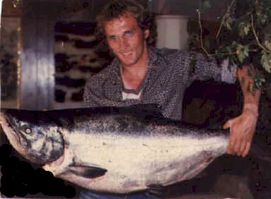
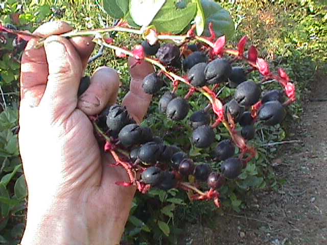
Vinland, the Viking’s plainly tell, contained
giant trees, giant salmon, and vines with fine, fat wine berries. These things don’t grow today in
Newfoundland and we have no evidence that they did when the climate was warmer. 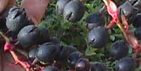 Eastern Canadian
salmon are smaller than Norwegian and even Swedish salmon- they would not have impressed
Vikings as immense. Neither would Eastern
Canadian trees. The salmon and trees of the
B.C. Coast are bigger than any recorded Scandinavian counterparts… they would have
looked awesome.
Eastern Canadian
salmon are smaller than Norwegian and even Swedish salmon- they would not have impressed
Vikings as immense. Neither would Eastern
Canadian trees. The salmon and trees of the
B.C. Coast are bigger than any recorded Scandinavian counterparts… they would have
looked awesome.
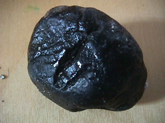
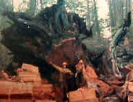
In Vinland they found Quartzite and Anthracite coal, you can’t find these
things on the East Coast.
![]() This is
anthracite coal and their is a quartzite deposit less then 2 miles up stream.
This is
anthracite coal and their is a quartzite deposit less then 2 miles up stream.
The coal comes from the smelter [winter cave]. on Vancouver island.

Leif Eriksson discovered Vinland in 996. That’s
important! From 800 to sometime between 1200
and 1400 AD. The Arctic Ice pack was far smaller than it has been since then. Viking sailors could roam the Arctic Ocean during
the warmer half of the year.. something nobody can do now.
Being
able to roam the Arctic, the Vikings almost certainly did.. such was their nature and
their navigational skills were already superb. Their
reports of latitude were accurate to less than half a degree, perhaps to a tenth or a
twentieth- a fact we will meet again. Map below…..
Vinland… The sagas tell
us that Eriksson’s first voyage to Vinland was a year long: about ten years after
returning to Greenland he came back with a larger party and stayed three years. Reading the old
accounts, I get a strong intuition that after Eriksson’s larger party abandoned
Vinland, parties from Scandinavia – the territories of what we know today as Iceland,Norway, Denmark,
and Sweden were Differently arranged then—tried to return to Vinland and never made
it back home.
When the arctic ocean froze over-- 1400 AD. or a bit earlier-- Viking travel was
restricted to the Arctic ocean and the Eurasian mainland. Regular sea travel through the
northwest passage never resumed, though special parties led by the heaviest ice breakers
can navigate the area [if the purpose, of the voyage justifies the immense cost.]It has
been centuries since people thought of the Arctic Ocean as open sea
To find Vinland, one must imagine the Vikings perspective, In a time the southern
Arctic Ocean was reliably open during the warm part of the year. Then the accounts in the
sagas make sense.
Leif's account begins in 995, in Greenland. Lief tells his father, Erik the Red, how
he was blown southward of course while in route from Iceland: 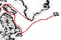 He
accidentally found two large Islands [today Newfoundland and Baffin island]and a part of
north American mainland [probably Labrador, Which would have been well wooded in that
warmer time]. He proposes to sail westward and explore what is obviously a large
amount of new land. [Saga quotations are in the translation found in Farley Mowat's
Far West.]
He
accidentally found two large Islands [today Newfoundland and Baffin island]and a part of
north American mainland [probably Labrador, Which would have been well wooded in that
warmer time]. He proposes to sail westward and explore what is obviously a large
amount of new land. [Saga quotations are in the translation found in Farley Mowat's
Far West.]
[See The lost Vikings]
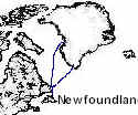
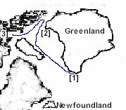 The saga continues..."They made their ship ready
for sea ;when all was ready they sailed ...reaching an island which lay to the northward
of the country[ the inhabited south of the west coast of Greenland].[1] see map 1 . They
went up and looked about in fine weather[2].After that they returned to their ship and
sailed through the sound which lay between the island and that cape which projected
northward from the land itself".[3]
The saga continues..."They made their ship ready
for sea ;when all was ready they sailed ...reaching an island which lay to the northward
of the country[ the inhabited south of the west coast of Greenland].[1] see map 1 . They
went up and looked about in fine weather[2].After that they returned to their ship and
sailed through the sound which lay between the island and that cape which projected
northward from the land itself".[3]
Heading northward [and a bit westward] from south Greenland [which is the only part of
that huge island that was ever inhabited] the large island one reaches is plainly Baffin
island; the translation doesn't tell me clearly if "they looked about them "
refers to exploring one island or several."up there" seems to me to refer to the
northward- projecting cape [ellesmere Island]. in any case, the sound they sailed
through after exploring Baffin island and probably some nearby islands is known as
Lancaster Sound.
"They sailed westward around the cape"[4]. contains the saga: and from the north
end of Baffin Island it is basically westward all the way to the north cape --
Alaska, at point Barrow.--- See Map#1
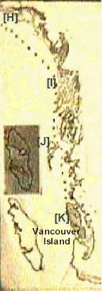 " There they found many hellur. there were many arctic foxes
there. They gave a name to this country and called it helluland[H]. From thence
they sailed for two days and bore away from the south toward the southeast, until they
reached a wooded country containing many animals[I]. An island lay off to the southeast of
this country[J]. Then they sailed southward along this land; after two days
they came to a cape" [K]. At this point they had reached Vinland.
" There they found many hellur. there were many arctic foxes
there. They gave a name to this country and called it helluland[H]. From thence
they sailed for two days and bore away from the south toward the southeast, until they
reached a wooded country containing many animals[I]. An island lay off to the southeast of
this country[J]. Then they sailed southward along this land; after two days
they came to a cape" [K]. At this point they had reached Vinland.
...... see Map # 2 .....
If the
directions were to sail south west for 1 week till you hit a wooded land, then sail south
along the coast till you hit a cape. From the cape, sail to the viking out post situated
on the rock[Newfouldland] Then yes "Vinland is Newfoundland" |
Vinland---Mowat's rendering of the sagas leaves room for
two interpretations--either lieafs party rounded the north part of Baffin island [sailing
a very short was westward] and then wound its way back through the north end of Hudson's
Bay, down Davis Strait off the coast of Labrador, to L'anse aux Meadows; or they
sailed a long way west and came down the west coast of north America. Between these coasts
there is no way to reach the 49th Parallel by sea-the southern end of James bay is at
latitude 5? . [in any case, the description of Vinland bears no resemblance to James bay.]
Obviously, there are gaps in the account; and to decide which coast Lief Erikson reached,
one must look at the length of the voyage and his description of the place.
The saga account doesn't cover 90 days; but it is recorded that it took that long. A
Viking ship could sail, say 100 miles in a day. The journey from southwest Greenland
through the Northwest passage, around Alaska, to the Alexander Archipelago; would total
less then 6000 miles. From there south to the 49th Parallel would be 500-600 miles.
A three month voyage could reach the west Coast with ample time for shore exploration;
while it would be wastefully long to go from Greenland to Newfoundland-- even around
Baffin island, and it is hard to imagine taking such a circuitous rout to a place Lief had
already reached by accident, and could have gone to more directly in a week or two!
Seen on a globe, the shortest route from Greenland to point Barrow is through the
northwest passage; and the halfway point of the joinery is located somewhere on the north
coast of Baffin Island.
Wherever the gap in the account may have been, sailing southeast from Alaska, via the
Alexander Archipelago and the Queen Charlotte Islands and or- the northern B.C. coast,
Lief's party would indeed have met trees and "many animals".
 By the time they reached the 49th parallel, those trees could have been 15-20
feet thick-- nowhere in Europe or Northeastern North America do we know of any tree more
than 6-8 feet thick; and those biggest trees include oaks and beaches with which the
Vikings would already have been similar. In a warmer climate, Newfoundland could have
contained 6 foot white pines , perhaps; but that's about the upper limit. Such trees
would not have been huge compared with what a similar "climate enhancement"
would have produced in Scandinavia. West Coast species, however, would have impressed even
Vikings. The same is true of the "huge salmon" to which the sagas refer:
Newfoundland salmon are smaller than Scandinavian salmon, which in turn are smaller than
Chinook salmon.
By the time they reached the 49th parallel, those trees could have been 15-20
feet thick-- nowhere in Europe or Northeastern North America do we know of any tree more
than 6-8 feet thick; and those biggest trees include oaks and beaches with which the
Vikings would already have been similar. In a warmer climate, Newfoundland could have
contained 6 foot white pines , perhaps; but that's about the upper limit. Such trees
would not have been huge compared with what a similar "climate enhancement"
would have produced in Scandinavia. West Coast species, however, would have impressed even
Vikings. The same is true of the "huge salmon" to which the sagas refer:
Newfoundland salmon are smaller than Scandinavian salmon, which in turn are smaller than
Chinook salmon.
The Vikings clearly refer to the "Island of
Vinland", and their Vinland map is a rough mirror image of Vancouver island.
The best interpretation I can make of this fact is two fold:
![]() They
knew the world was round; and the Vinland Image is reversed to Symbolize that Vinland is
on the other side of the world.
They
knew the world was round; and the Vinland Image is reversed to Symbolize that Vinland is
on the other side of the world.
Sailing the northernmost waters , the Vikings would have ready evidence that longitudinal
distances were shorter, the farther north one goes. This might have been much less
evident to low-latitude sailors; because the closer one gets to the pole, the greater the
effect of a north south difference. Having traveled to or beyond the equator, they would
also have noticed that day lengths differ both by season and by latitude
"Discoveries can only happen when you go where something is -- you cannot find it
where it is not. We need to remember to listen to the views and stories of others, and be
willing to accept them. "
Native legends, some of them published, tell of stories of Vikings having visited this
coast. If we accept the truthfulness of the Vikings, they tell us how to find Vinland: It
is a three-month voyage from Greenland. Newfoundland is not. Giant trees and salmon are
here, not on the northwest peninsula of Newfoundland. The Vinland map looks more like our
Island then "The Rock".
With In paddling distance of where I sit now sits the Remains of the most famous lost
Viking kingdom ever"Vinland"
more to come
On to Vinland 1999