An island on the 49th parallel ,where they found 
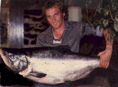
trees as big as houses ,salmon larger then any thing they had ever seen. On
this island a berry droops of a vein and makes the best wine. A place so mild ,no snow
covers the ground during the winter and it's a 3 month voyage from Greenland .
These stories can be found from India through Europe to
Greenland,
but the most amazing one is the one on a boulder in Spokane Washington
[H]. In 1926 the story was deciphered by Professor Oluf Opajon, a Scandinavian scientist.
He says that 6 Vikings survived a ferocious attack, after the attack they returned to bury
the dead .Left alone in Vinland, they had to find their own way home. It is written that
they saw carved images of Thor, Odin and Freya during their swim.
 The Vikings where incredible river travelers.
They would know that if they where stranded on the west coast of N.A. their only way to
get home would be to travel the largest river system inland, connect with the opposite
system. They would probably mark their path where they crossed overland by
righting in stone, so that other survivors would know where to cross.
The Vikings where incredible river travelers.
They would know that if they where stranded on the west coast of N.A. their only way to
get home would be to travel the largest river system inland, connect with the opposite
system. They would probably mark their path where they crossed overland by
righting in stone, so that other survivors would know where to cross.

 My
theory is that they left Vinland [K] and headed to the
biggest river the Columbia river [L], they paddled small
canoe's up to Spokane where they wrote their story on a
bolder[M], from here they headed overland to the Bow river[N], from the bow they would portage to the great
lakes, this was where the Kensington stone was found[O].Through the great lakes[P] then
north to Newfoundland.[Q]Where they
awaited rescue from Greenland ,which was inevitable. How could the Vikings see giant trees
in Newfoundland,a place they do not grow.
My
theory is that they left Vinland [K] and headed to the
biggest river the Columbia river [L], they paddled small
canoe's up to Spokane where they wrote their story on a
bolder[M], from here they headed overland to the Bow river[N], from the bow they would portage to the great
lakes, this was where the Kensington stone was found[O].Through the great lakes[P] then
north to Newfoundland.[Q]Where they
awaited rescue from Greenland ,which was inevitable. How could the Vikings see giant trees
in Newfoundland,a place they do not grow.
That's just my theory